Conservation Mapping Process Finally Yields Tool for Prioritization of Land Conservation Opportunities
What do you do when you have a big problem to solve and limited resources at your disposal to do so?
You need a plan and a really good one, especially if the money you're spending is coming from the hard work of local taxpayers and the generosity of local donors.
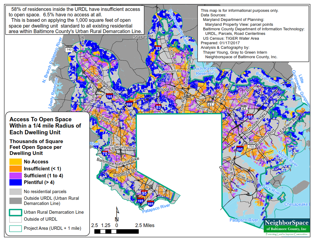
We have a big problem in Baltimore County that's challenging not only because of its magnitude, but also because of what it means for aging neighborhoods. As shown below, sixty-five percent of residents inside the URDL in Baltimore County lack adequate access to open space with in a five-minute walk from home. Over half of the housing stock inside the URDL in Baltimore County is pre-1970. Without substantial upgrades, many neighborhoods inside the URDL will have a hard time competing for expected growth with newer communities in neighboring jurisdictions like Harford and Howard counties. This is a threat to the one thing that has allowed current county leaders to achieve a Triple A bond rating and to tout this accomplishment like an Olympic gold medal: the County's strong tax base.
Thomas Vicinno, someone I have quoted often in posts like this one because of the extent to which he has studied our situation, paints our plight in a less rosy light. In his 2008 book, Transforming Race and Class in Suburbia, Decline in Metropolitan Baltimore, he lays bare our challenges, citing information from our Planning Office indicating that more than 70 percent of the county's housing stock is aged 30 years or older and much of it is lacking in modern amenities or suffering from some type of obsolescence. He cites County data noting that 100,000 people are without health insurance and 47,000 households are living close to the poverty level. Based on his research, he ultimately proclaims that: "Baltimore County ... has reached a crossroads. The road to more decline may be an easy path to folllow. It requires doing nothing and maintaining the status quo. The road to success depends on the political and social willingness to confront the decline of its suburbs."
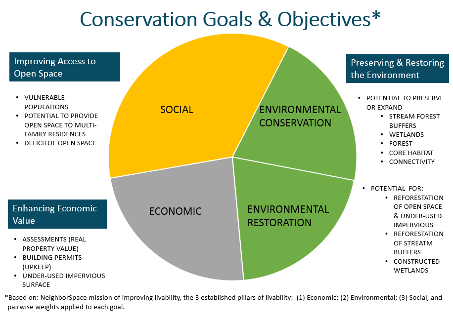
We want to be on the flow of Vicinno's tide and not on its ebb. And we think the best way to do that is to doggedly pursue a conservation plan that is based on values that our constituents have said are important to them. The chart below illustrates those values, which have been vetted with constituents and GIS experts and weighted through a process known as "pairwise comparison."
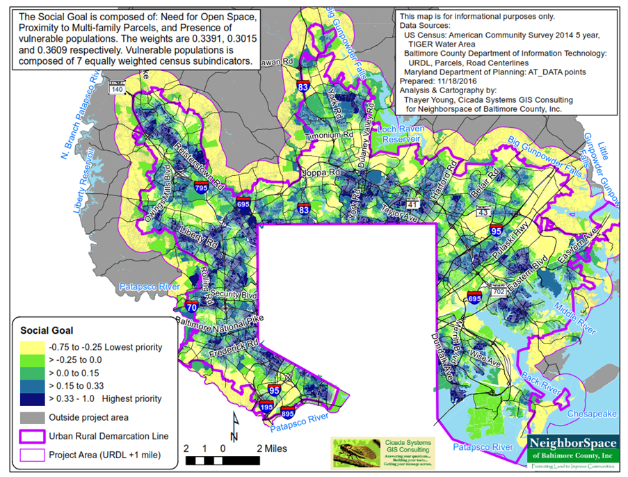
When these values (represented by GIS layers) are overlaid onto the earth and graded on the extent to which they are present on the ground, a map like the one below for the social goal takes shape, indicating where priorities for achieving that goal are highest:
At a scale of 1 inch equals 2 miles, it's hard to see vacant land or underutilized impervious surface that might be acquired and preserved as open space. Zooming in on an area yields the following map for Towson:
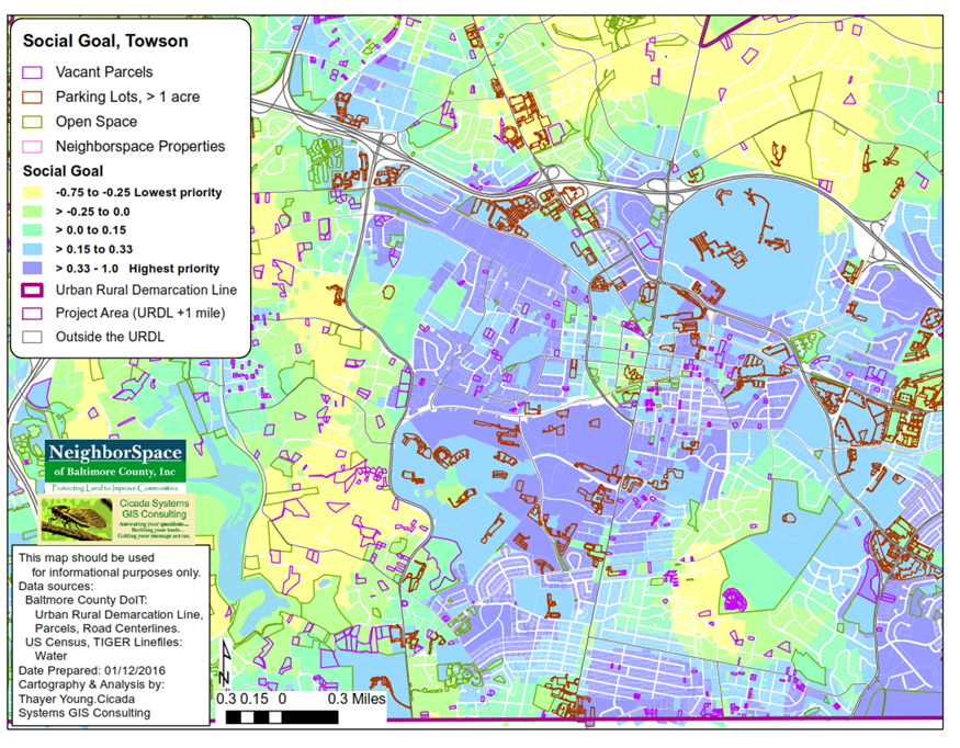
At this scale, we are able to see both vacant parcels and parking lots with the social priorities overlaid. The model tells us that the parcels in the the violet areas of the map are the ones we should prioritize for conservation.
As for next steps, we want to vet the model with those who helped us to produce it. We will also begin using the model to create a strategic conservation plan. In that plan, we will develop our priorities for conserving land inside the URDL to deliver on our mission of improving livability within communities there.