A "How to" Guide on Using Green Infrastructure to Tackle Today's Health Challenges
In the 19th century, we piped clean water into people’s homes and began treating wastewater. Communicable diseases were wiped out and life expectancy skyrocketed. In the 20th century, we lowered infectious disease rates with regular vaccinations. A new guide caught our eye recently, which suggests that smart investments in green infrastructure in the 21st century can have at least the impact on human health that sanitation and vaccination investments had in the 19th and 20th centuries, respectively.
What do we mean by “green infrastructure?” The “green” aspect of “green infrastructure” refers to elements in the landscape like streams, wetlands, trees, trails and open space.
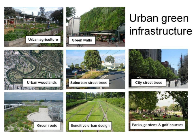
The “infrastructure” part of “green infrastructure” refers to how these elements can be used to achieve certain goals, like managing stormwater runoff, reducing heat in urban areas, providing wildlife habitat, creating park space, and improving our resilience to climate change.
The new resource, called the Green Infrastructure and Health Guide, suggests that by engaging the public, and properly locating and designing green infrastructure, we can improve physical activity, mental health, social relationships, air quality and other health factors. In this way, green infrastructure becomes the 21st century elixir for some of the most devastating public health issues of our time, e.g., heart disease, cancer, diabetes, depression.
This resource could help to advance many projects important to those of you who have supported NeighborSpace. For several years, we’ve been providing technical assistance to an effort to construct the Md. Line Trail, a spur of the Star-Spangled Banner Trail that is proposed for an area along Bear Creek in Dundalk. Here is a green infrastructure project that, when built, has the potential to provide a 1.25 mile walking trail for local residents and students of the four public schools along which the proposed route passes.
Another similar effort is the Six Bridge Trail project proposed for an area along Herring Run in Towson, which would connect several neighborhoods and pocket parks in East Towson to downtown Towson. The NeighborSpace mapping tool that so many of you helped to fund was a source of GIS support for this terrific project. It will definitely be a tool for working with communities to identify more green infrastructure projects inside the URDL. See for yourself what the Green Infrastructure and Health Guide has to offer.