Guest Article by Daniel Dean
Daniel Dean is the research chair for the Marshy Point Nature Center Council, a member of the Archeological Society of Maryland, and a member of the Maryland Free-State Treasure Club. In addition to historical research, he has been unearthing the physical items of Marshy Point park with the help of the Central Chapter of the ASM and permission from the Baltimore County Parks and Recreation director. In this article, Daniel shares some of his recent discoveries about Volz Neighborhood Park.
In January of this past year, mutual friend Kathy Martin of Marshy Point Nature Center Council and NeighborSpace of Baltimore County reached out to me with a few opportunities she thought I may be interested in joining. One of the events was a walking group with a DNR Natural Resources Planner at Volz Park in Middle River. As someone who enjoys nature and the hidden history below the trees and leaves, I took Kathy up on the invitation and started the journey back in time. What few realize is that our current sections of wooded areas may have been cleared fields over 200 years ago, with new settlers setting up homes and farmland. It is true that there were vast woods of untouched grounds as well, but once colonial settlements took place, we had an onslaught on the trees and brush across the region. These trees were needed for building, heating, and the large industry of iron works. The furnaces at the forges required large amounts of fuel to gain the heat needed for this production. With that in mind, remember the importance of replanting and replenishing the earth and how grateful we are to have organizations like NeighborSpace of Baltimore County allowing the new generation of woodland to stay safe from falling into the next clearing for communities as our population grows.
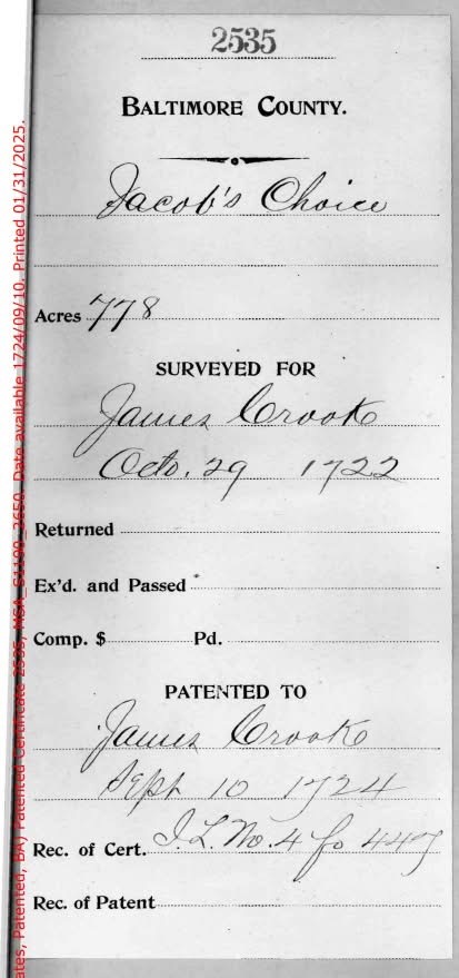
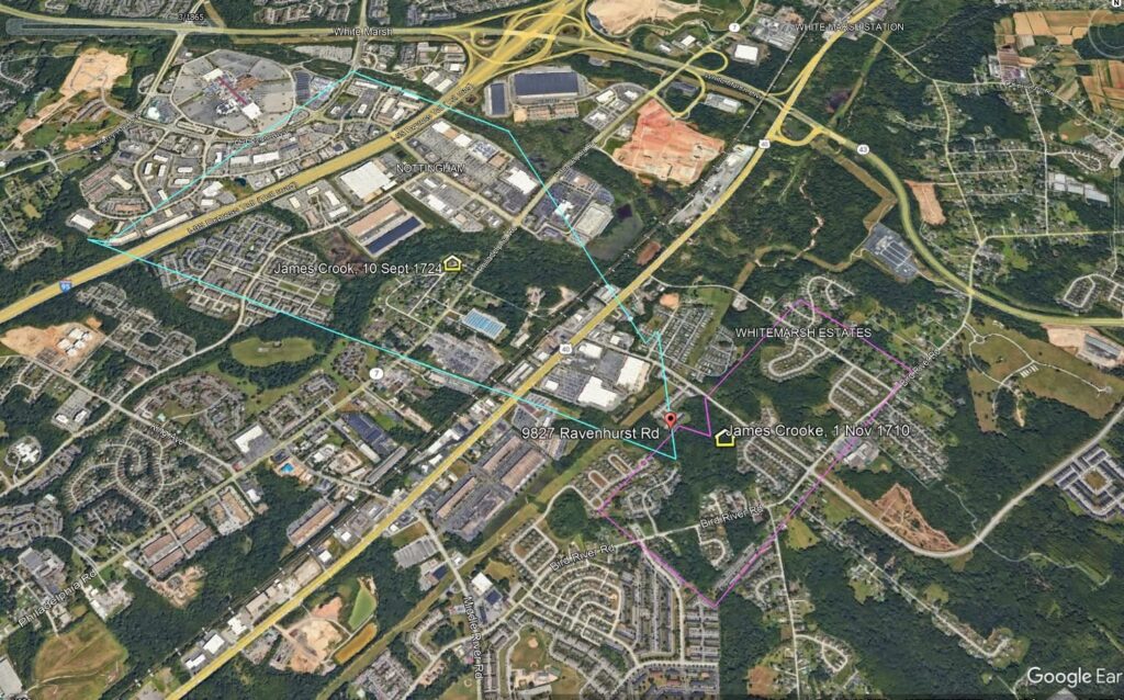
This story is about historic survival. It tells the story of a tree from centuries ago and the mystery of its disappearance from our memory. The area has an interesting recorded history dating back to the 18th century with two primary land patents, which fall within this 14-acre park. One section of this park is within a land patent called “Jacob’s Choice” (1724). The other section is in “Doggwood Thickett” (1710). Although the lands can overlap and transform over the years with different landowners, I focused on these two patent names using KML data transferred from map-maker.org and various historical maps. It was a beautifully crisp day for this walk in the old boundaries. We did not see any Dogwood trees or bushes, but our guide was very informative with his knowledge.
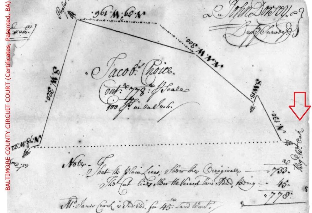
One of the interesting historical features which stand out is a Big White Oak Tree. It is mentioned in the land patent for Jacob’s Choice (1722 survey, 1724 patent). Over the years, there is mention in the 1877 Hopkins Map of Baltimore County with “Big Jacobs Choice,” the 1898 and the 1915 Bromley map with the same “Big Jacobs Choice” designated. There is a tree symbol on each map at the same location as the original land patent.

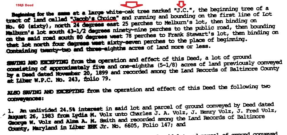
On the land deed from 03/18/1985, Book 6911, Page 306, there is mention of a large white oak tree as the boundary. It is even marked with a “J.C.” and mentioned as the beginning tree for the tract of land called Jacob’s Choice. There is a possibility of this carrying over from previous deeds, unless recently surveyed in the 1980s.
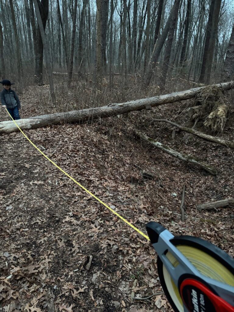
Sadly, on my second visit to this park on February 5th, 2025, to see if this tree still existed, I only found two visibly possible areas where this “Big White Oak” may have once stood. There is a large pit which stands out in the wooded area. It is the size of a large cellar hole and has one single cinder block at the bottom. Looking over aerial images dating back to the 1950s, this area was all wooded and there was no farming at the location of the tree. There is an offshoot stream, part of White Marsh Run, and it could have been a spring house at one time but it is hard to tell. The second suspected site, which matched with the map location better, is an open area that has been taken over by brush and is inaccessible without clearing out the thicket. It is dense with few trees in close proximity.
The merchant owner who held both land patents, James Crooke, has a very interesting past and a case of slander where he was accused by a widow with allegations against him in 1704. Her fiancé called off their wedding based on some vulgar language he used in reference to their relationship. We find this in the publication, Fortune’s Orphan: The Troubled Career of Thomas Macnemara in Maryland, 1703-1719, by C. Ashley Ellefson. A lot more can be learned of this property with interesting possibilities for these open green areas in the future.
As the Research Chair for Marshy Point Nature Center Council, I speak with groups dealing with history and nature. It is important to keep both perspectives in the foreground as history is easily forgotten within parks. Even the most mundane walkways, sport fields, and perimeters of development existed in another form since the beginning of the Earth we stand on aside from movement from man or nature. As we change our landscape, let us continue to honor the life it had and those who interacted with it.